 |
Mountain-City
is nestled in the Appalachian Mountains in the extreme northeastern corner of Tennessee, near the North Carolina border. The town serves as the county seat for Johnson County, which is the eastern-most county in the state. Mountain City is a beautiful little town, with a population of around 2,400 residents. It is near the spectacular Blue Ridge Parkway and the ski slopes of Boone, North Carolina. Hiking is a common activity along the wooded mountain trails, and fishing in the rivers, streams and lakes near Mountain City is especially popular. Watauga Lake is the closest to Mountain City and is well stocked on a yearly basis. Watauga, which is a Native American word for "beautiful waters," is the highest reservoir in the Tennessee River system at 1,900 feet above sea level. Aside from excellent fishing, other activities on and around the lake include swimming, boating, water skiing and camping. Mountain City is also an easy day trip to the Great Smoky Mountains National Park and the cities of Gatlinburg, Pigeon Forge and Cherokee, Tennessee. The Johnson County Welcome Center & Museum is located in Mountain City and other nearby attractions include Backbone Rock Recreation Area and Gentry's Creek Falls. The latter is one of the most photographed waterfalls in northeast Tennessee, where a two and a half-mile trail leads to two waterfalls (30 and 40 feet high.)
Surrounding areas: Butler, Tennessee (14.3 mi), Watauga Lake, Tennessee (20.5 mi), Bristol, Tennessee (22.8 mi), Roan Mountain, Tennessee (24.3 mi), Bluff City, Tennessee (25.3 mi), Hampton, Tennessee (26.1 mi), Johnson City, Tennessee (33.0 mi)
|

|
Mountain City Vacation Rentals
|

|
|
|
|
|
Mountain City Hotels and Resorts
|
|
|
| | | Hotels & Motels |
| Hampton Inn Abingdon | 340 Commerce Dr | Abingdon, VA | 18.2 mi. | (276) 619-4600 | | Holiday Inn Express | 940 E Main St | Abingdon, VA | 18.2 mi. | (276) 676-2829 | | Quality Inn & Suites | 930 E Main St | Abingdon, VA | 18.2 mi. | (276) 676-9090 | | Super 8 Motel | 298 Towne Centre Dr | Abingdon, VA | 18.4 mi. | (276) 676-3329 | | Jefferson Landing | | Jefferson, NC | 18.8 mi. | (336) 982-4449 | | Comfort Inn | 170 Jonesboro Rd | Abingdon, VA | 18.9 mi. | (276) 676-2222 | | Comfort Suites Abingdon | 1093 Ole Berry Dr | Abingdon, VA | 18.9 mi. | (276) 698-3040 | | Martha Washington Inn | 150 West Main St | Abingdon, VA | 18.9 mi. | (276) 628-3161 | | Comfort Suites | 1184 Hwy 105 | Boone, NC | 19.2 mi. | (828) 268-0099 | | Hampton Inn Boone | 1075 Hwy 105 | Boone, NC | 19.2 mi. | (828) 264-0077 | | High Country Inn | 1785 Hwy 105 | Boone, NC | 19.2 mi. | (828) 264-1000 | | Super 8 Motel | 2419 Hwy 105 S | Boone, NC | 19.2 mi. | (828) 264-4133 | | The Homecoming Lodge | 5335 NC Hwy 194 N | Boone, NC | 19.2 mi. | (828) 264-8413 | | Best Western Blue Ridge Plaza | 840 E King St | Boone, NC | 19.3 mi. | (828) 266-1100 | | Country Inn And Suites Boone | 818 E King St | Boone, NC | 19.3 mi. | (828) 264-4100 | | Best Western Eldreth Inn | 829 E Main St | Jefferson, NC | 19.8 mi. | (336) 246-8845 | | Quality Inn Appalachian Conference CTR | 949 Blowing Rock Rd | Boone, NC | 20.0 mi. | (828) 262-0020 | | La Quinta Inn #933 - Bristol | 1014 Old Airport Rd | Bristol, VA | 20.5 mi. | (276) 669-9353 | | Travelodge Glade Spring | 12412 Maple St | Glade Spring, VA | 20.5 mi. | (276) 429-5131 | | Courtyard By Marriott Bristol | 3169 Linden Dr | Bristol, VA | 20.7 mi. | (276) 591-4400 | | Holiday Inn Of Boone | 710 Blowing Rock Rd | Boone, NC | 20.8 mi. | (828) 264-2451 | | Holiday Inn Hotel & Suites | 3005 Linden Dr | Bristol, VA | 21.0 mi. | (276) 466-4100 | | Holiday Inn Express | 1943 Blowing Rock Rd | Boone, NC | 21.1 mi. | (828) 264-2451 | | Sugar Mountain Ski And Country Club | | Banner Elk, NC | 21.8 mi. | (828) 898-9784 | | Comfort Inn | 2368 Lee Hwy | Bristol, VA | 21.9 mi. | (276) 466-3881 | | Super 8 Motel Bristol | 2139 Lee Hwy | Bristol, VA | 22.1 mi. | (276) 466-8800 | | Regency Inn | 975 Volunteer Pkwy | Bristol, TN | 22.5 mi. | (423) 968-9474 | | Microtel Inn & Suites Bristol | 131 Bristol East Rd | Bristol, VA | 22.9 mi. | (276) 669-8164 | | Econo Lodge | 912 Commonwealth Ave | Bristol, VA | 23.4 mi. | (276) 466-2112 | | Howard Johnson Inn | 2221 Euclid Ave | Bristol, VA | 24.0 mi. | (276) 669-7171 | | Knights Inn | 2221-2 Euclid Ave | Bristol, VA | 24.0 mi. | (276) 669-7171 | | Comfort Inn-elizabethton | 1515 19e Byp | Elizabethton, TN | 24.2 mi. | (423) 542-4466 | | Alpen Acres | 156 Old US Hwy 321 S | Blowing Rock, NC | 24.5 mi. | (828) 295-7981 | | Chetola Resort & Conference Center | | Blowing Rock, NC | 24.5 mi. | (800) 243-8652 | | Chetola Resort & Conference | | Blowing Rock, NC | 24.5 mi. | (828) 295-5500 | | Days Inn Blowing Rock | Hwy 321 Byp | Blowing Rock, NC | 24.5 mi. | (828) 295-4422 | | Ridgeway Motor Inn | Hwy 221 | Blowing Rock, NC | 24.5 mi. | (828) 295-7321 | | Hampton Inn | 3299 W State St | Bristol, TN | 26.3 mi. | (423) 764-3600 | | Bristol Lodging Services LLC | 111 Holiday Dr | Bristol, TN | 26.6 mi. | (423) 968-1101 | | Eseeola Lodge | 175 Linville Ave | Linville, NC | 28.4 mi. | (828) 733-4311 |

|
Mountain City Weather & Climate
|

|
|
|
The mountainous Northeast region of Tennessee has a temperate climate with moderately cold winters and warm, humid summers. Precipitation is distributed fairly evenly throughout the year so there is no distinct wet or dry seasons. October has the least rainfall, July the most. Snowfall is variable from year to year, and some winters have relatively little. Thunderstorms occur anytime of the year, but are most frequent in spring and summer. Summer temperatures are rarely extreme, but the high humidity often makes it seem hotter than it actually is. Severe storms are infrequent in the state, being east of the center of tornado activity, south of most blizzard conditions, and too far inland to be affected by hurricanes.
|
| Month |
High Temp |
Low Temp |
Rainfall |
Ocean Temp |
| January |
43°F |
19°F |
3.85 in. |
- |
| February |
47°F |
22°F |
4.08 in. |
- |
| March |
55°F |
29°F |
4.68 in. |
- |
| April |
64°F |
36°F |
3.99 in. |
- |
| May |
72°F |
45°F |
5.23 in. |
- |
| June |
79°F |
53°F |
4.22 in. |
- |
| July |
82°F |
58°F |
4.25 in. |
- |
| August |
81°F |
56°F |
3.87 in. |
- |
| September |
76°F |
50°F |
3.57 in. |
- |
| October |
66°F |
36°F |
2.80 in. |
- |
| November |
56°F |
29°F |
3.13 in. |
- |
| December |
47°F |
22°F |
3.84 in. |
- |

|
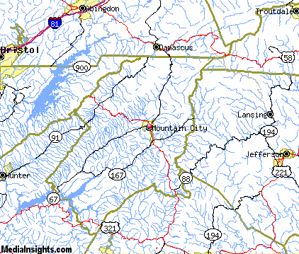
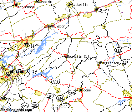
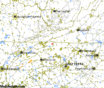
Mountain City Map & Transportation
|

|
|
 |
|
|
| Click each thumbnail image to enlarge. |
 |
|
 |
 |
The closest airports in the area are the Tri Cities Regional Tn Va airport (TRI) located about 33 miles west of Mountain City in Bristol Johnson Kingsport, Tennessee, the Wilkes County airport (UKF) located approximately 43 miles southeast of Mountain City in North Wilkesboro, North Carolina, the Hickory Regional airport (HKY) located roughly 55 miles south of Mountain City in Hickory, North Carolina, and finally the Greeneville Greene County Municipal airport (GCY) located around 59 miles west of Mountain City in Greeneville, Tennessee.
|

|
Mountain City Attractions
|

|
|
| | | Water Parks |
| Paramount's Carowinds-Water Works | Pineville | NC | 108.9 mi. | | | Emerald Pointe Water Park | Greensboro | NC | 115.5 mi. | |
| | | Golf Courses |
| Roan Valley Golf Estates | Mountain City | TN | | | | Bear Trace at Tims Ford State Park | Winchester | TN | 8.4 mi. | | | Deer Field Golf Course | Damascus | VA | 11.1 mi. | | | Tillery Tradition Country Club | Mount Gilead | NC | 15.7 mi. | | | Mountain Aire Golf Club | West Jefferson | NC | 16.7 mi. | | | Boone Golf Club | Boone | NC | 19.7 mi. | | | Willow Creek Golf Course | Boone | NC | 19.7 mi. | | | Village of Sugar Mountain Golf Course | Banner Elk | NC | 22.1 mi. | | | Clear Creek Golf Club | Bristol | VA | 22.3 mi. | | | Hawksnest Golf & Ski Resort | Seven Devils | NC | 22.5 mi. | | | Steel Creek Golf Course | Bristol | TN | 22.8 mi. | | | Scenic View Golf Course | Chilhowie | VA | 22.9 mi. | | | Elizabethton Municipal Golf Course | Elizabethton | TN | 24.4 mi. | | | Mountain Glen Golf Course | Newland | NC | 27.6 mi. | | | Saltville Golf Course | Saltville | VA | 28.1 mi. | | | Holston Hills Country Club | Marion | VA | 28.8 mi. | | | Tri Cities Golf Course | Blountville | TN | 28.9 mi. | |
| | | Ski Areas |
| Ski Beech | Banner Elk | NC | 21.8 mi. | | | Sugar Mountain Ski Area | Banner Elk | NC | 21.8 mi. | | | Hawksnest Golf & Ski Resort | Seven Devils | NC | 21.9 mi. | | | Ski Wolf Laurel | Mars Hill | NC | 61.1 mi. | | | Winterplace | Flat Top | WV | 86.1 mi. | | | Canaan Valley | Davis | WV | 94.7 mi. | | | Cataloochee | Maggie Valley | NC | 97.9 mi. | |
| | | State Parks |
| Mount Jefferson State Park | | NC | 19.9 mi. | | | Grayson Highlands State Park | | VA | 20.2 mi. | | | Hungry Mother State Park | | VA | 32.2 mi. | | | Rendezvous Mountain State Park | | NC | 33.6 mi. | | | Warriors Path State Park | | TN | 37.5 mi. | |
| | | Museums |
| Carroll Reece Museum | Johnson City | TN | 32.5 mi. | (Multidisciplinary) | | Hands On! Regional Museum | Johnson City | TN | 32.5 mi. | (Children's) | | Hickory Museum of Art | Hickory | NC | 57.4 mi. | (Art) |
| | | Zoos and Aquariums |
| Western North Carolina Nature Center | Asheville | NC | 73.5 mi. | | | Greenville Zoo | Greenville | SC | 116.8 mi. | | | Mill Mountain Zoo | Roanoke | VA | 116.8 mi. | |
Notice a problem with the information on this page? Please notify us.
|
Disclaimer: We recommend you conduct your own research regarding all accomodations and attractions found on this website. The distances shown on this website are straight-line distances as the crow flies. The road distance may be considerably longer. You assume all liability for use of any information found on this website. No information is confirmed or warranted in any way. By using our services you agree to the terms and conditions of this disclaimer.
|
| We are the #1 site for your Tennessee Vacations presenting Tennessee vacation rentals, hotels, weather and map for each city. |
Tennessee Vacations .com
©1997-2024 All Rights Reserved.
|
|